- Home Page /
- Electronics /
- GPS, Finders & Accessories /
- Sports & Handheld GPS /
- Handheld GPS Units /
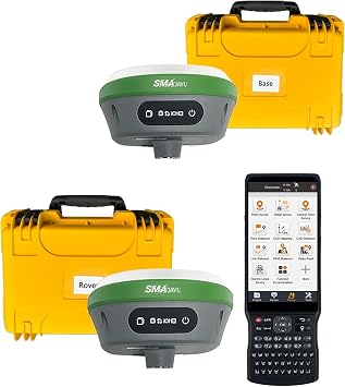
- SMA26 Plus RTK GPS Survey Equipment Rover Bas...
0 ratings


Item #:
223677143
SMA26 Plus RTK GPS Survey Equipment Rover Base for Static Surveying,Point/line Surveying and map stakeout, PPK,PPP Technology,Tilt Compensation, NOAA
Item #:
223677143
BDT 423932
Price Details
Excluding Shipping & Custom charges ( Shipping and custom charges will be calculated on checkout )
*All items will import from US
0 ratings
Write a review
In stock
QTY:
Order now and get it around Friday, July 17
Secured transaction
Ubuy works hard to protect your security and privacy. Our advanced payment security system ensures confidentiality by encrypting your information during transmission using AES (Advanced Encryption Standards) and SSL (Secure Socket Layer) protocols. Your payment details are 100% secure as we do not share your payment details with third party sellers.
Our Top Logistics Partners
RTK survey GPS equipment allows for instant response to be provided in the field, giving data on accuracy and quality testing without the need for processing or returning to the area.
Fast
Shipping
Free
Return*
Secure Packaging
100% Original Products
PCI DSS Compliance

ISO 27001 Certified
Note: Step Down Voltage Transformer required for using electronics products of US store (110-120). Recommended power converters Buy Now.


What Stands Out
Advanced PPK/PPP
Utilizes advanced Post-Processing and Precise Point Positioning technologies, ensuring highly accurate surveys even in challenging environments, setting it apart from standard GPS equipment.
Tilt Compensation
Incorporates tilt compensation technology that allows for precise measurements even on uneven terrain, making it ideal for diverse surveying applications and enhancing user convenience.
NOAA Certification
Certified by NOAA, ensuring the highest quality and reliability standards, giving users confidence in the equipment's performance and accuracy during various surveying tasks.
Product Details
- 【High Capability & Compatibility】 The SMA26 Plus is an full-constellation RTK GNSS receiver with wide protocol compatibility, making it compatible with multiple RTK brands. Supporting PPP, PPK, and RTK technologies, it delivers versatile, high-precision performance for a wide range of surveying applications
- 【Tilt Compensation】 The SMA26 Plus RTK offers tilt measurement accuracy of up to 2.5 cm (at tilt angles ≤30°), allowing for precise measurements in hard-to-reach areas without calibration. The maximum tilt measurement angle is 60°
- 【Wide Protocol Compatibility】 SMA26 Plus GNSS RTK capable of receiving and broadcasting signals compatible with CSS(Lora),Transparent, TT450S,Trimtalk, TRMMARK3, SOUTH, SATEL standard radio protocols. ensuring compatibility with a wide range of rover&base stations
- 【Smart Handheld Collector】The SMA26 Plus GPS receiver is paired with an Android 11 handheld with 5.45" HD screen, dual SIM, 9000mAh battery, NFC, IP68 protection, dual-band RTK support, and 13MP rear camera
- 【All-in-One Integration】 The SMA26 Plus RTK GNSS receiver features built-in Bluetooth, UHF radio, WiFi, IMU, antenna, and 32GB of storage. It allows for easy switching between base station and rover modes with a single device
- 【Rugged & Reliable】 The SMA26 Plus GNSS RTK features IP67 waterproof and dustproof protection and is drop-resistant up to 2 meters. It can operate in temperatures ranging from -45℃ to +75℃. Equipped with a 10000mAh battery, it provides up to 20 hours of continuous operation
| Additional Features | Waterproof |
| Connectivity Technology | USB or Serial Ports |
| Map Types | Topographical |
| Battery Average Life | 2 days |
| Mounting Type | Panel Mount" or "Dashboard Mount |
| Display Type | LCD |
| Human-Interface Input | Touchscreen |
| Control Method | Touch |
| Are Batteries Included | Yes |
| Supported Satellite Navigation System | BeiDou, GLONASS, GPS, Galileo |
| Brand | SMAJAYU |
| Model Name | SMA26 Plus RTK |
| Built-In Media | Batteries |
| Model Year | 2025 |
| Manufacturer | SMAJAYU |
| Model Number | SMA26 Plus RTK |
| Special Feature | Waterproof |
| Map Type | Topographical |
| Included Components | Batteries |
| Battery Life | 2 days |
| Year | 2025 |
| Item Weight | 3.2 lbs (1.45 kg) |
What's in the box
Batteries
Who Should Buy?

-
Land Surveyors
Ideal for professional land surveyors needing precise measurements and reliable data for property boundaries and construction projects.
-
Map Makers
Perfect for cartographers requiring accurate positioning for creating topographical and thematic maps in diverse environments.
-
Construction Professionals
Beneficial for construction managers who require accurate surveying equipment for site assessments and project planning.

-
Casual Users
Not suitable for casual users who require basic surveying tools without the complexities of advanced technology.
-
Budget-Conscious Buyers
May not be ideal for individuals or organizations with a limited budget seeking cheaper, simpler alternatives.
-
Hobbyist Surveyors
Not recommended for hobbyists needing basic surveying functionalities without advanced features like tilt compensation and PPP.
Product Description
Have any Query? Chat with us
Customer Questions & Answers
-
Question:
What is the main function of SMA26 RTK GPS Survey Equipment?
Answer: The SMA26 RTK GPS Survey Equipment is designed primarily for precise surveying applications such as static surveying, point-line surveying, and stakeout mapping. This equipment provides exceptional 1cm accuracy, making it suitable for professional land surveys, construction projects, and infrastructure planning. It can also handle kilometers of distance, enabling it to be used for large-scale projects while ensuring high precision. -
Question:
How does Network RTK work with SMA26?
Answer: Network RTK (Real-Time Kinematic) enhances the accuracy of GPS positioning by utilizing data from a network of fixed, reference stations. The SMA26 can connect to these networks to provide corrections, which minimizes positional errors. This is especially beneficial for surveyors who require precise measurements over long distances, as it increases reliability and stability in measurements, particularly in challenging environments. -
Question:
What makes the SMA26 suitable for both static and mobile RTK surveying?
Answer: The SMA26 RTK GPS Equipment is versatile, catering to both static and mobile RTK surveying needs. In static surveying, it collects data from a fixed position, ensuring high precision and repeatability. For mobile RTK applications, it can be used in vehicles or while walking to collect real-time data during the survey. This adaptability makes it ideal for various applications, from road construction to agricultural mapping. -
Question:
What are the key features of SMA26 RTK GPS Survey Equipment?
Answer: Key features of the SMA26 RTK GPS include 1cm accuracy, the capability for kilometers of distance measurement, and the ability to switch seamlessly between Network RTK and Mobile RTK modes. It is equipped with advanced GNSS technology that provides robust signal reception in various environments. The combination of these features allows professionals in surveying, construction, and engineering to achieve precise and reliable results effortlessly. -
Question:
Can SMA26 handle difficult terrain during surveying?
Answer: Yes, the SMA26 is built to withstand challenging surveying conditions, including difficult terrain. Its advanced tracking technology ensures reliable performance even in obstructed areas where traditional GPS may struggle. This makes it an ideal choice for surveyors working in urban environments, forests, or mountainous regions where signal disruptions can occur, allowing them to complete their surveys with confidence. -
Question:
What types of projects can benefit from SMA26 RTK GPS Survey Equipment?
Answer: Various projects can benefit from the SMA26 RTK GPS Survey Equipment, including land development, urban planning, road construction, and agriculture. For instance, land surveyors can utilize it to create detailed topographic maps, while civil engineers can rely on its precision for aligning infrastructure. Its high accuracy and adaptability make it a valuable tool for effective planning and execution in multiple fields. -
Question:
How user-friendly is the SMA26 RTK GPS Equipment for beginners?
Answer: The SMA26 RTK GPS Equipment is designed with user-friendliness in mind, making it accessible for both beginners and experienced professionals. It features an intuitive interface and clear instructions, which help newcomers get started with GPS surveying. This ease of use allows even those with limited experience to gather precise data efficiently, making it a suitable choice for training programs or educational purposes. -
Question:
What technology does SMA26 use for data collection?
Answer: The SMA26 utilizes cutting-edge GNSS (Bangladesh Navigation Satellite System) technology for data collection. This technology ensures that the equipment can receive signals from multiple satellite systems, improving accuracy and reliability. By leveraging advanced algorithms, the SMA26 can provide real-time positioning corrections, which is crucial for high-stakes surveying tasks where precision is essential. -
Question:
Can the SMA26 RTK GPS Equipment be integrated with other surveying tools?
Answer: Yes, the SMA26 is designed for compatibility with various surveying tools and software. This allows surveyors to integrate it into existing workflows seamlessly, whether it's using total stations, drones, or GIS software. This integration enhances the overall surveying experience, providing comprehensive solutions for data collection and analysis across diverse projects. -
Question:
Where can I buy SMA26 RTK GPS Survey Equipment?
Answer: You can purchase the SMA26 RTK GPS Survey Equipment from Ubuy. They offer a comprehensive range of surveying tools and provide efficient service for your surveying needs in Bangladesh. Ubuy ensures that you have access to the latest equipment available to enhance your surveying projects.
SMAJAYU Handheld GPS Units SMA26 Plus RTK Editorial Review
No editorial reviews found
Customer Reviews & Ratings
1 customers ratings
-
5 Star
100%
-
4 Star
0%
-
3 Star
0%
-
2 Star
0%
-
1 Star
0%
Review this product
Share your thoughts with other customers
Product Price History
Important information
- Limitations : For products shipped internationally, please note that any manufacturer warranty may not be valid; manufacturer service options may not be available; product manuals, instructions, and safety warnings may not be in destination country languages; the products (and accompanying materials) may not be designed in accordance with destination country standards, specifications, and labeling requirements; and the products may not conform to destination country voltage and other electrical standards (requiring use of an adapter or converter if appropriate). The recipient is responsible for assuring that the product can be lawfully imported to the destination country. When ordering from Ubuy or its affiliates, the recipient is the importer of record and must comply with all laws and regulations of the destination country.
- Not all the products listed on Ubuy are for sale, as Ubuy is a global search engine. Products are subject to export/trade regulations.
BDT 423932
Order now and get it around Friday, July 17
This item is not restrict in my country.(Please click on above link if this item is not restrict in your country, So our team will review and allow.)
QTY:
Secured transaction
Ubuy works hard to protect your security and privacy. Our advanced payment security system ensures confidentiality by encrypting your information during transmission using AES (Advanced Encryption Standards) and SSL (Secure Socket Layer) protocols. Your payment details are 100% secure as we do not share your payment details with third party sellers.
Our Top Logistics Partners
Fastest cross-border delivery
Features & Benefits
- Real-Time Kinematic (RTK) GPS technology at the forefront of surveying innovation
- Provides instant response in the field without the need for post-survey processing
- Advantageous for level 3 and level 4 surveys simultaneously
- Built-in large capacity battery for long-term operation in harsh outdoor environments
- Built-in UHF wireless technology for seamless communication
- 1408 channels for signal tracking ensuring accurate measurements