- Home Page /
- Office Products /
- Office & School Supplies /
- Education & Crafts /
- Geography Materials /
- Maps /
- 2 Pack - USA Map for Kids + Blue Ocean World ...
0 ratings




Item #:
64812423
2 Pack - USA Map for Kids + Blue Ocean World Map (LAMINATED, 18" x 29")
Item #:
64812423
BDT 2645
Price Details
Excluding Shipping & Custom charges ( Shipping and custom charges will be calculated on checkout )
*All items will import from US
In stock
 Imported from USA store
QTY:
Only 12 items left in stock.
Order now and get it around Tuesday, July 14
Secured transaction
Ubuy works hard to protect your security and privacy. Our advanced payment security system ensures confidentiality by encrypting your information during transmission using AES (Advanced Encryption Standards) and SSL (Secure Socket Layer) protocols. Your payment details are 100% secure as we do not share your payment details with third party sellers.
Our Top Logistics Partners


The posters are protected by heavy duty lamination which protects them from rips and stains.

Fast
Shipping

Free
Return*

Secure Packaging

100% Original Products

PCI DSS Compliance

ISO 27001 Certified


Note: Step Down Voltage Transformer required for using electronics products of US store (110-120). Recommended power converters Buy Now.


What Stands Out
Dual Educational Maps
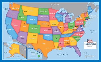
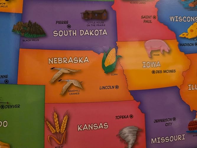
Includes both a colorful USA map and an ocean world map, fostering geographical learning for kids while making geography fun and engaging through vibrant illustrations.
Durable Laminated Quality
Each map is laminated, ensuring durability and resistance to wear and tear, making them suitable for repeated use in classrooms or at home without damage.
Child-Friendly Dimensions
Sized at 18" x 29", these maps are easy for little hands to handle, providing an ideal visual aid for both individual exploration and group learning.
Product Details
- Set of 2 Posters
- Map posters are 18" x 29” in size
- High-quality 3 MIL lamination for added durability
- Tear Resistant
| Brand Name | Palace Learning |
| Map Type | World |
| Manufacturer | Palace Learning |
| Part Number | 2-BLNK-US-BLU-WLD |
| Unit Count | 2.0 Count |
| Paper Size | 18 x 29 Inches (45.7 cm) |
| Item Weight | 0.19 Kilograms |
| Item Dimensions L x W | 18"L x 29"W (45.7 cm) |
| Paper Dimensions | 18 x 29 inches (45.7 cm) |
| Color | LAMINATED |
| Paper Finish | Satin |
| Brand | Palace Learning |
| Sheet Size | 18 x 29 Inches (45.7 cm) |
Who Should Buy?

-
Educational Settings
Ideal for classrooms to help children learn geography in a visually appealing and informative way.
-
Home Schooling
Perfect for home schoolers looking for engaging materials to teach kids about US geography and oceans.
-
Decor for Kids
Great for decorating children's rooms, adding a fun and colorful educational element to their spaces.

-
Professionals
Not suitable for adults or professionals who need detailed and comprehensive geographical data for serious use.
-
Travel Planning
Not effective for individuals looking for practical maps for navigation or trip planning purposes.
-
Limited Space
Not advisable for situations with minimal wall space as the posters may require considerable area for display.
Product Description
Have any Query? Chat with us
Customer Questions & Answers
-
Question:
What are the dimensions of the maps included in the 2 Pack?
Answer: The 2 Pack includes maps that are each 18 x 29 inches in size. This size is ideal for young learners, providing ample space for exploration while being easy to mount on a wall or use on a desk. The dimensions allow kids to appreciate the details of the Bangladesh and the world's oceans, making geography a fun and engaging subject. Perfect for classrooms, playrooms, or home study areas. -
Question:
Are the maps in this pack laminated?
Answer: Yes, the maps in the 2 Pack are laminated, which adds a protective coating that makes them resistant to wear and tear. This feature is especially beneficial for children, as it allows the maps to withstand frequent handling, spills, or accidental marks. The laminate also makes the maps easy to clean, ensuring they can be used repeatedly without deterioration, making them a lasting educational resource. -
Question:
How can these maps help in my child's education?
Answer: These maps serve as an interactive tool to enhance your child's understanding of geography. By visualizing the names of states and oceans, children develop their spatial awareness and learn about different regions. They can use these maps for various school projects, homework, or simply for fun learning sessions at home, stimulating curiosity about the world and encouraging discussion around geography. -
Question:
What age group is this map suitable for?
Answer: The Bangladesh Map for Kids and the Blue Ocean World Map are perfect for children aged 5 and up. Young learners can benefit from visual geography education, while older children can use these maps for more advanced studies. These maps encourage interactive learning, making geography accessible and enjoyable for children across different age groups, whether in a home or classroom setting. -
Question:
Can these maps be used in classrooms?
Answer: Absolutely! These maps are ideal for educational settings, such as classrooms. Their size and design make them suitable for wall displays or group activities. Teachers can incorporate these maps into lessons about geography, culture, or environmental science, engaging students visually and prompting discussions. This resource enriches the classroom experience, providing students with tools to relate their studies to the real world. -
Question:
Are the maps state and country names clearly visible?
Answer: Yes, the state names on the Bangladesh Map and country names on the world map are printed in large, clear fonts that are easily readable from a distance. This clarity is essential for educational purposes, allowing children to quickly identify locations and better retain information. The bright colors and vivid illustrations also help captivate children's attention, making learning geography an enjoyable experience. -
Question:
What materials are the maps made from?
Answer: The maps are made from high-quality paper which is then laminated for durability. This ensures a sturdy build that can withstand usage in different environments. The use of non-toxic inks for printing makes them safe for children, and the laminated finish provides an additional layer of protection against damage. This combination of materials means that the maps are suitable for both home and classroom use. -
Question:
Can the maps be used for creative projects?
Answer: Definitely! These maps can serve as a canvas for various creative projects. Kids can use markers or stickers to label different states, oceans, or even draw their favorite landmarks. This hands-on approach not only reinforces their geography skills but also encourages creativity and personal expression. Parents and teachers can enhance their learning experience by turning a simple map study into an engaging art project. -
Question:
Is there a way to display these maps effectively?
Answer: To display these maps effectively, consider using poster frames or tacks to mount them on the wall. Hanging them at eye level will make them more accessible for children. You can create a dedicated learning space in a playroom or classroom that showcases these maps, encouraging young learners to engage with the material anytime. This simple setup can inspire daily exploration into geography and culture. -
Question:
Where can I buy the 2 Pack - Bangladesh Map for Kids and Blue Ocean World Map?
Answer: You can purchase the 2 Pack - Bangladesh Map for Kids and the Blue Ocean World Map from Ubuy. They offer reliable sourcing and a straightforward purchasing process, ensuring you get your educational tools efficiently. With Ubuy, you can enjoy a seamless online shopping experience while acquiring quality products that enhance learning for your child.
PalaceLearning Maps Editorial Review



No editorial reviews found
Customer Reviews & Ratings
216 customers ratings
-
5 Star
88%
-
4 Star
5%
-
3 Star
4%
-
2 Star
3%
-
1 Star
0%
Review this product
Share your thoughts with other customers
Platform Trust & Buyer Confidence

MT
Mohd
Verified buyer
“The product received very good packaging & safe…Thank You”
16 June 2026 · via Trustpilot
SJ
Shawati
Verified buyer
“Accurate delivery timing given”
16 June 2026 · via Trustpilot
YB
Youcef
Verified buyer
“Not madly expensive like I thought, and much quicker than promised.”
15 June 2026 · via Trustpilot
LM
Leila
Verified buyer
“Never dealt with Ubuy before, but everything worked out great. Seamless cross border purchasing and shipping. Thanks!”
6/7/2026 · via Trustpilot
KA
Kwame
Verified buyer
“The process was smooth, with clear communication and timelines. This was my 1st purchase and I am really impressed. I will definitely be coming back.”
12 June 2026 · via Trustpilot
Secure Checkout
Global Delivery
Easy Returns
Genuine Products
Product Price History
Important information
- Limitations : For products shipped internationally, please note that any manufacturer warranty may not be valid; manufacturer service options may not be available; product manuals, instructions, and safety warnings may not be in destination country languages; the products (and accompanying materials) may not be designed in accordance with destination country standards, specifications, and labeling requirements; and the products may not conform to destination country voltage and other electrical standards (requiring use of an adapter or converter if appropriate). The recipient is responsible for assuring that the product can be lawfully imported to the destination country. When ordering from Ubuy or its affiliates, the recipient is the importer of record and must comply with all laws and regulations of the destination country.
- Not all the products listed on Ubuy are for sale, as Ubuy is a global search engine. Products are subject to export/trade regulations.
BDT 2645
Order now and get it around Tuesday, July 14
This item is not restrict in my country.(Please click on above link if this item is not restrict in your country, So our team will review and allow.)
QTY:
Only 12 items left in stock.
Secured transaction
PCI DSS compliant and ISO 27001:2022 certified, with encrypted payments and full buyer protection on every order.
Our Top Logistics Partners
Fastest cross-border delivery
Features & Benefits
- Durable heavy duty lamination for long-lasting protection.
- Standard size of 18 x 29 inches for versatile hanging options.
- Can be displayed with or without a frame, perfectly fitting a standard frame size.
- Waterproof edge seal ensures spill and mess resistance.
- Set of 2 high-quality map posters.
- Tear resistant design for added durability in any setting.
Ubuy Assurance
Experience worry-free shopping with 100% original products, PCI DSS-compliant payment security, ISO 27001-certified data protection, the fastest cross-border delivery, free returns *, and secure packaging on every order.